Even if I originally created this site with the purpose of sharing with you my cycling tours
around different parts of Europe, as you've probably (and rightly) guessed, I do not tour
full time, regrettably...
Most of the year I cycle around home, and I've finally decided it was a pity this
didn't show at all in my page.
Not only home is where I do most of my cycling, but after
some touring abroad I've realized that I really shouldn't
complain too much: after all, I live in one of the most beautiful
places in the world...
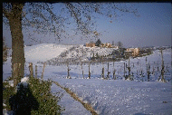
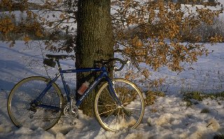
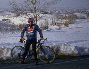
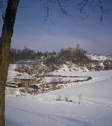 The itinerary I show here is one of my favourites when the days are short and I only get
a couple of hours at most to be around. From home it's a 50-60 km. loop. Of course,
we do not really get snow that frequently, but this winter I've been lucky, and this gave me the
opportunity to show you these pictures (Including the one above
to show that it was really me out there...). And here to the right is a view of the fortified
citadel of Crespellano, just
after the road starts to climb from the plain of the river Po.
The itinerary I show here is one of my favourites when the days are short and I only get
a couple of hours at most to be around. From home it's a 50-60 km. loop. Of course,
we do not really get snow that frequently, but this winter I've been lucky, and this gave me the
opportunity to show you these pictures (Including the one above
to show that it was really me out there...). And here to the right is a view of the fortified
citadel of Crespellano, just
after the road starts to climb from the plain of the river Po.
 The river Po, of course, is 80 km. away to the north (the Pianura padana is
Italy's largest plain). I live near the foothills of the Appennini, luckily
enough, within cycling reach of them (you won't belive how boring it gets cycling
in the plains after a while...) To these days, the Via Emilia (Aemilia in latin),
an ancient roman road, follows these same foothills from the Adriatic coast to
Milan. The region where I live, Emilia-Romagna, is named after the road, and all
its largest towns, Bologna and Modena among them, are to be found along the path traced
by a consul from the Gens Aemilia about 2300 years ago.
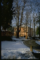
Here to the left is a fairly typical Emilian villa:
a brickwork structure covered
with plaster painted in bright, warm hues, most common: yellow, ochre, salmon.
The river Po, of course, is 80 km. away to the north (the Pianura padana is
Italy's largest plain). I live near the foothills of the Appennini, luckily
enough, within cycling reach of them (you won't belive how boring it gets cycling
in the plains after a while...) To these days, the Via Emilia (Aemilia in latin),
an ancient roman road, follows these same foothills from the Adriatic coast to
Milan. The region where I live, Emilia-Romagna, is named after the road, and all
its largest towns, Bologna and Modena among them, are to be found along the path traced
by a consul from the Gens Aemilia about 2300 years ago.
Here to the left is a fairly typical Emilian villa:
a brickwork structure covered
with plaster painted in bright, warm hues, most common: yellow, ochre, salmon.
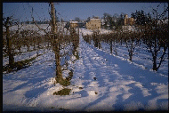
 The road that I follow on the first part of this itinerary crests a hill with views over
the plain on one side and the Appennines on the other. It finally descends in the valley
of the river Samoggia with a rather steep plunge (right),
to get to the town of Monteveglio. The town features a medieval abbey on the top of the
hill opposite from this view (hidden by the cypresses...).
The road that I follow on the first part of this itinerary crests a hill with views over
the plain on one side and the Appennines on the other. It finally descends in the valley
of the river Samoggia with a rather steep plunge (right),
to get to the town of Monteveglio. The town features a medieval abbey on the top of the
hill opposite from this view (hidden by the cypresses...).
 A second climb starts from the town of Bazzano, dominated by a heavily restored but
imposing rocca (medieval citadel, which includes a castle and a pieve,
or parish church) and again follows a hilltop to get to the small chapel of Montebudello.
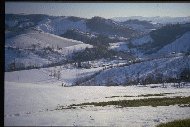
To the east the view embraces a narrow and rather secluded valley
(left), which, in this heavily populated area, can almost be described as wilderness...
A second climb starts from the town of Bazzano, dominated by a heavily restored but
imposing rocca (medieval citadel, which includes a castle and a pieve,
or parish church) and again follows a hilltop to get to the small chapel of Montebudello.
To the east the view embraces a narrow and rather secluded valley
(left), which, in this heavily populated area, can almost be described as wilderness...
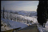
 To the west from Montebudello a slighly larger, more open valley, through which the road
that closes the loop descends (right), provides another
enchanting wiew. This is one of my favourites stretches,
where the landscape represents this region at its best: gently undulating slopes covered
with vineyards, farms, cultivated fields and small irrigation ponds.
To the west from Montebudello a slighly larger, more open valley, through which the road
that closes the loop descends (right), provides another
enchanting wiew. This is one of my favourites stretches,
where the landscape represents this region at its best: gently undulating slopes covered
with vineyards, farms, cultivated fields and small irrigation ponds.
 In the distance appears the citadel of Savignano perched on the hills that enclose the valley of the
Panaro river (left) , and beyond, the town of Vignola, with its
castle strategically placed at the point where the Panaro flows from the foothills into the
plain. This is a point where more serious rides for warmer times start, some of which I hope
I'll be able to show to you in a very near future.
In the distance appears the citadel of Savignano perched on the hills that enclose the valley of the
Panaro river (left) , and beyond, the town of Vignola, with its
castle strategically placed at the point where the Panaro flows from the foothills into the
plain. This is a point where more serious rides for warmer times start, some of which I hope
I'll be able to show to you in a very near future.


 Even if I originally created this site with the purpose of sharing with you my cycling tours
around different parts of Europe, as you've probably (and rightly) guessed, I do not tour
full time, regrettably...
Most of the year I cycle around home, and I've finally decided it was a pity this
didn't show at all in my page.
Even if I originally created this site with the purpose of sharing with you my cycling tours
around different parts of Europe, as you've probably (and rightly) guessed, I do not tour
full time, regrettably...
Most of the year I cycle around home, and I've finally decided it was a pity this
didn't show at all in my page.